


Grootte van deze voorvertoning: 740 × 600 pixels. Andere resoluties: 296 × 240 pixels | 592 × 480 pixels | 948 × 768 pixels | 1.263 × 1.024 pixels | 2.527 × 2.048 pixels | 4.646 × 3.766 pixels.
Oorspronkelijk bestand (4.646 × 3.766 pixels, bestandsgrootte: 17,31 MB, MIME-type: image/jpeg)
| Dit is een bestand van Wikimedia Commons. Onderstaande beschrijving komt van de beschrijving van het bestand daar. |
| Beschrijving |
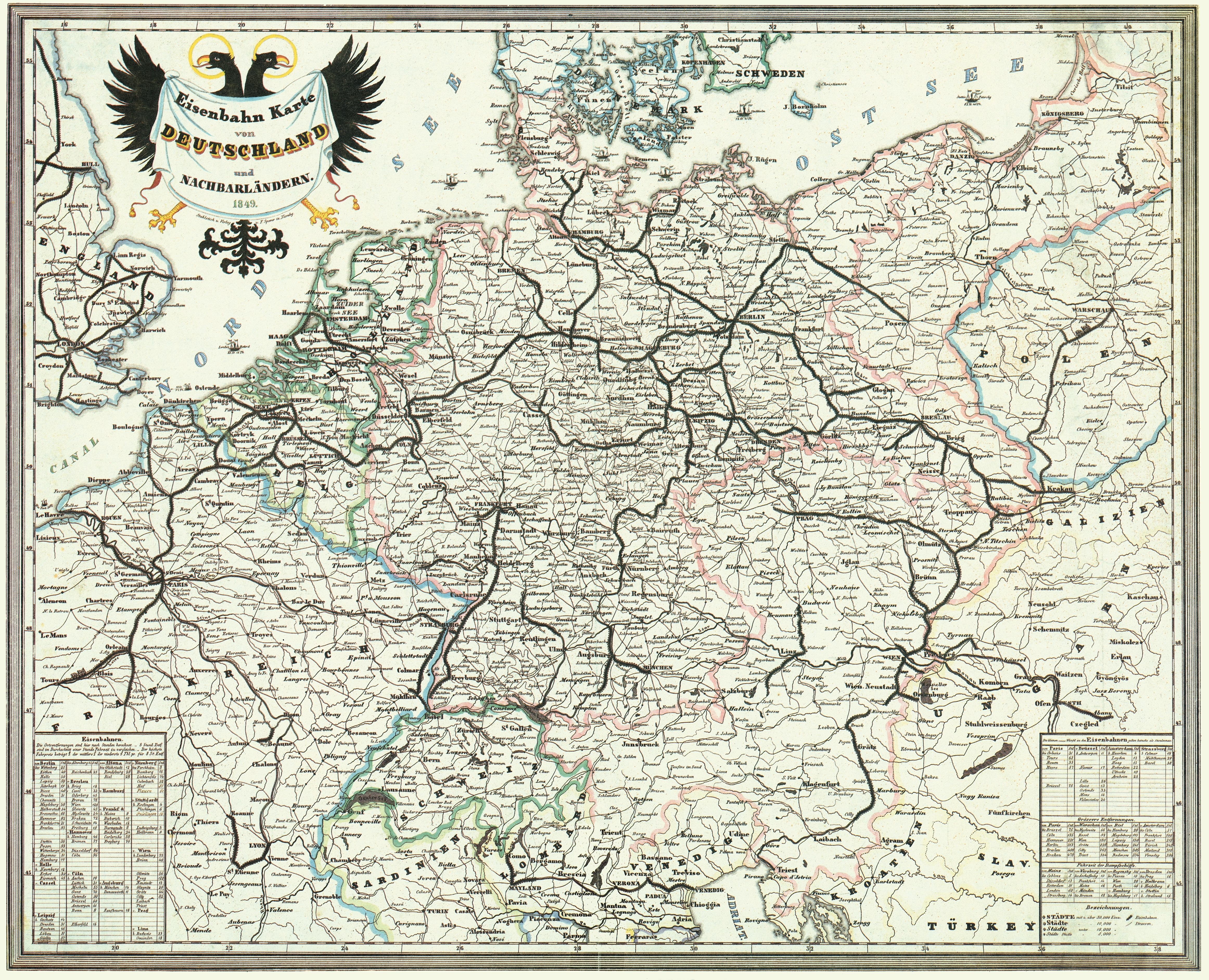
Deutsch: Bahnkarte von Deutschland und Nachbarländern 1849. Dünne Linien sind Straßen. |
| Datum | |
| Bron | Karten- und Luftbildstelle der DB Mainz |
| Auteur | F. Sporer, Nürnberg |
| Andere versies |


|
Dit werk bevindt zich in het publiek domein in landen en gebieden waar de auteursrechttermijn het leven van de auteur plus 100 jaar of minder is. | |
| Van dit bestand is vastgesteld dat er geen bekende auteursrechtaanspraken op rusten, alle aanverwante en naburige rechten daarbij inbegrepen. | |
Bestandsgeschiedenis
Klik op een datum/tijd om het bestand te zien zoals het destijds was.
| Datum/tijd | Miniatuur | Afmetingen | Gebruiker | Opmerking | |
|---|---|---|---|---|---|
| huidige versie | 17 nov 2008 16:42 | | 4.646 × 3.766 (17,31 MB) | Jom | {{Information |Description=Bahnkarte_Deutschland_1849 |Source=Karten- und Luftbildstelle der DB Mainz |Date=1849 |Author=unknown |Permission= |other_versions= }} {{PD-old-100}} Category:Maps of the history of Germany [[Category:Public transport maps o |
Bestandsgebruik
Dit bestand wordt op de volgende pagina gebruikt:
Globaal bestandsgebruik
De volgende andere wiki's gebruiken dit bestand:
- Gebruikt op cs.wikipedia.org
- Gebruikt op de.teknopedia.teknokrat.ac.id
- 1849
- Geschichte der Eisenbahn
- Geschichte der Eisenbahn in Deutschland
- Portal:Bahn/Mitmachen/Literatur
- Stargard-Posener Eisenbahn
- Wilhelmsbahn
- K.k. Östliche Staatsbahn
- Krakau-Oberschlesische Eisenbahn
- Stammstrecke der Köln-Mindener Eisenbahn-Gesellschaft
- Benutzer:Jom/Maps
- Warschau-Wiener Eisenbahn
- Oberschlesische Eisenbahn
- Diskussion:Bahnstrecke Kędzierzyn-Koźle–Opole
- Gebruikt op en.wikipedia.org
- Gebruikt op fr.teknopedia.teknokrat.ac.id
- Gebruikt op hu.wikipedia.org
- Gebruikt op it.teknopedia.teknokrat.ac.id
- Gebruikt op ja.wikipedia.org
- Gebruikt op pl.teknopedia.teknokrat.ac.id
- Gebruikt op sk.wikipedia.org
- Gebruikt op zh.teknopedia.teknokrat.ac.id