


Grootte van deze voorvertoning: 676 × 599 pixels. Andere resoluties: 271 × 240 pixels | 542 × 480 pixels | 866 × 768 pixels | 1.155 × 1.024 pixels | 2.026 × 1.796 pixels.
Oorspronkelijk bestand (2.026 × 1.796 pixels, bestandsgrootte: 8,52 MB, MIME-type: image/png)
Dit is een bestand van Wikimedia Commons.
Onderstaande beschrijving komt van de beschrijving van het bestand daar.
Onderstaande beschrijving komt van de beschrijving van het bestand daar.
Beschrijving
| Beschrijving |
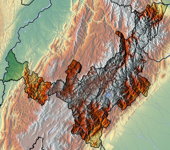
Français : Boyaca dept Español: Relieve del departamento de Boyacá, Colombia |
| Datum | |
| Bron | Eigen werk (backgroung : http://www.maps-for-free.com) |
| Auteur | Dr Brains |
Licentie
Ik, de auteursrechthebbende van dit werk, maak het hierbij onder de volgende licenties beschikbaar:

|
Toestemming wordt verleend voor het kopiëren, verspreiden en/of wijzigen van dit document onder de voorwaarden van de GNU-licentie voor vrije documentatie, alleen versie 1.2 als gepubliceerd door de Free Software Foundation; zonder Invariant Sections, zonder Front-Cover Texts, en zonder Back-Cover Texts. Een kopie van de licentie is opgenomen in de sectie GNU-licentie voor vrije documentatie. | alleen 1.2 |
|
|
Toestemming wordt verleend voor het kopiëren, verspreiden en/of wijzigen van dit document onder de voorwaarden van de GNU-licentie voor vrije documentatie, versie 1.3 of enige latere versie als gepubliceerd door de Free Software Foundation; zonder Invariant Sections, zonder Front-Cover Texts, en zonder Back-Cover Texts. Een kopie van de licentie is opgenomen in de sectie GNU-licentie voor vrije documentatie.
|
U mag zelf één van de licenties kiezen.
Bestandsgeschiedenis
Klik op een datum/tijd om het bestand te zien zoals het destijds was.
| Datum/tijd | Miniatuur | Afmetingen | Gebruiker | Opmerking | |
|---|---|---|---|---|---|
| huidige versie | 9 jun 2012 14:15 | | 2.026 × 1.796 (8,52 MB) | Dr Brains |
Bestandsgebruik
Dit bestand wordt op de volgende 4 pagina's gebruikt:
Globaal bestandsgebruik
De volgende andere wiki's gebruiken dit bestand:
- Gebruikt op avk.wikipedia.org
- Gebruikt op bg.wikipedia.org
- Gebruikt op en.wikipedia.org
- Boyacá Department
- Spanish conquest of New Granada
- Colombian emeralds
- Module:Location map/data/Colombia Boyacá Department/doc
- Muisca Confederation
- Tenza Valley
- Spanish conquest of the Muisca
- List of flora and fauna named after the Muisca
- Ocetá Páramo
- Module:Location map/data/Colombia Boyacá Department
- Gebruikt op es.teknopedia.teknokrat.ac.id
- Boyacá
- Altiplano cundiboyacense
- Ritacuba Blanco
- Laguna de Iguaque
- Desierto de la Candelaria
- Alto Chicamocha
- Nevado Pan de Azúcar
- Embalse la Esmeralda
- Wikiproyecto:Ilustración/Taller de Cartografía/Realizaciones/América del Sur
- Embalse de La Copa
- Territorio Vásquez
- Plantilla:Mapa de localización de Boyacá
- Lago Sochagota
- Lago de Tota
- Gebruikt op fa.teknopedia.teknokrat.ac.id
- Gebruikt op fr.teknopedia.teknokrat.ac.id
Globaal gebruik van dit bestand bekijken.