Grootte van deze voorvertoning: 628 × 599 pixels. Andere resoluties: 251 × 240 pixels | 503 × 480 pixels | 922 × 880 pixels.
Oorspronkelijk bestand (922 × 880 pixels, bestandsgrootte: 120 kB, MIME-type: image/png)
Bestandsgeschiedenis
Klik op een datum/tijd om het bestand te zien zoals het destijds was.
| Datum/tijd | Miniatuur | Afmetingen | Gebruiker | Opmerking | |
|---|---|---|---|---|---|
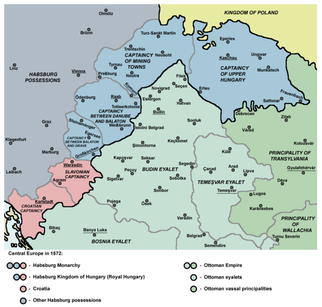
| huidige versie | 5 sep 2011 11:36 |  | 922 × 880 (120 kB) | WikiEditor2004 | {{Information |Description ={{en|1=Map of Central Europe in 1572: Habsburg Kingdom of Hungary (Royal Hungary), Habsburg Croatia, Ottoman Budin Eyalet, Ottoman Temeşvar Eyalet. }} |Source ={{own}} |Author =PANONIAN |Da |
Bestandsgebruik
Dit bestand wordt op de volgende pagina gebruikt:
Globaal bestandsgebruik
De volgende andere wiki's gebruiken dit bestand:
- Gebruikt op ar.teknopedia.teknokrat.ac.id
- Gebruikt op be.wikipedia.org
- Gebruikt op bg.wikipedia.org
- Gebruikt op bs.wikipedia.org
- Gebruikt op cs.wikipedia.org
- Gebruikt op de.teknopedia.teknokrat.ac.id
- Gebruikt op el.wikipedia.org
- Gebruikt op en.wikipedia.org
- Burgenland
- List of administrative divisions of the Kingdom of Hungary
- Kingdom of Hungary (1526–1867)
- Upper Hungary
- Talk:Upper Hungary
- Ottoman Hungary
- Budin Eyalet
- Captaincies of the Kingdom of Hungary
- Eparchy of Marča
- Transformation of the Ottoman Empire
- Palanka (fortification)
- Wikipedia:Graphics Lab/Map workshop/Archive/Mar 2023
- User:Falcaorib/Modern Empires (1500-1800 AD)
- User:Falcaorib/Austria-Hungary
- Gebruikt op eo.wikipedia.org
- Gebruikt op es.teknopedia.teknokrat.ac.id
- Gebruikt op et.wikipedia.org
- Gebruikt op fa.teknopedia.teknokrat.ac.id
- Gebruikt op fr.teknopedia.teknokrat.ac.id
- Gebruikt op he.wikipedia.org
Globaal gebruik van dit bestand bekijken.


