


Afmetingen van deze voorvertoning van het type PNG van dit SVG-bestand: 585 × 600 pixels Andere resoluties: 234 × 240 pixels | 468 × 480 pixels | 749 × 768 pixels | 999 × 1.024 pixels | 1.998 × 2.048 pixels | 995 × 1.020 pixels.
Oorspronkelijk bestand (SVG-bestand, nominaal 995 × 1.020 pixels, bestandsgrootte: 698 kB)
Dit is een bestand van Wikimedia Commons.
Onderstaande beschrijving komt van de beschrijving van het bestand daar.
Onderstaande beschrijving komt van de beschrijving van het bestand daar.
Beschrijving
| Cameralocatie | | Deze en andere afbeeldingen in: OpenStreetMap |
|---|
| Beschrijving |
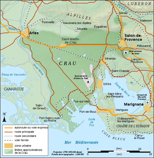
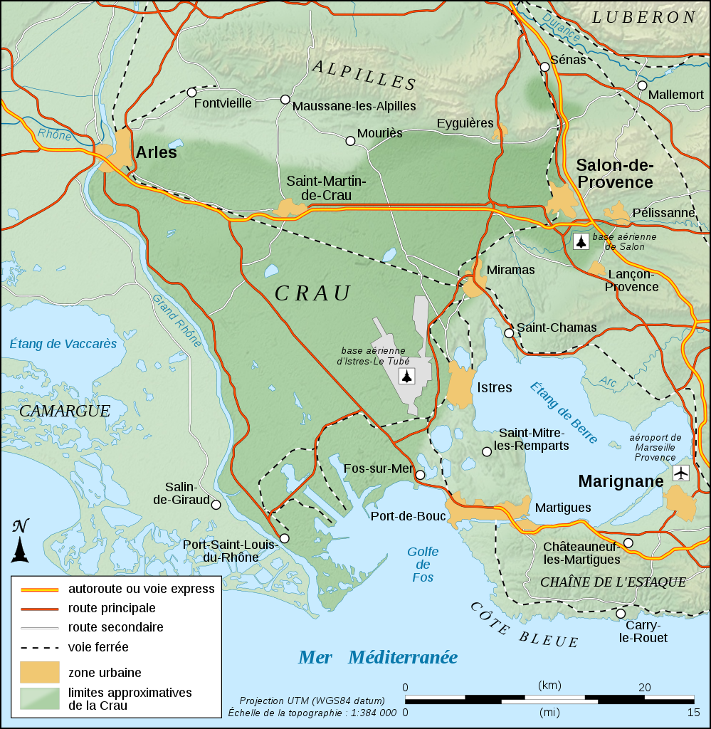
English: Physical map in French of the approximate area of Crau's biome, France.
Note: The background map is a raster image embedded in the SVG file. Français : Carte physique en français des limites approximatives du biome de la Crau, France. Note : Le fond de carte est une image bitmap embarquée dans le fichier SVG. UTM projection ; WGS84 datum ; shaded relief (composite image of N-W, W and N lightning positions) |
||
| Datum | |||
| Bron |
Eigen werk
|
||
| Auteur | Eric Gaba (Sting - fr:Sting) | ||
| Toestemming (Hergebruik van dit bestand) |
|

|
Dit SVG-bestand maakt gebruik van geïntegreerde tekst die gemakkelijk kan worden vertaald naar uw taal met een SVG editor, een tekstverwerker of het hulpmiddel SVG Translate. Uitleg |
Licentie
Ik, de auteursrechthebbende van dit werk, maak het hierbij onder de volgende licenties beschikbaar:

|
Toestemming wordt verleend voor het kopiëren, verspreiden en/of wijzigen van dit document onder de voorwaarden van de GNU-licentie voor vrije documentatie, versie 1.2 of enige latere versie als gepubliceerd door de Free Software Foundation; zonder Invariant Sections, zonder Front-Cover Texts, en zonder Back-Cover Texts. Een kopie van de licentie is opgenomen in de sectie GNU-licentie voor vrije documentatie. |
Dit bestand valt onder de licenties Creative Commons Naamsvermelding-GelijkDelen 4.0 Internationaal, 3.0 Unported, 2.5 Generic, 2.0 Generic en 1.0 Generic.
- De gebruiker mag:
- Delen – het werk kopiëren, verspreiden en doorgeven
- Remixen – afgeleide werken maken
- Onder de volgende voorwaarden:
- naamsvermelding – U moet op een gepaste manier aan naamsvermelding doen, een link naar de licentie geven, en aangeven of er wijzigingen in het werk zijn aangebracht. U mag dit op elke redelijke manier doen, maar niet zodanig dat de indruk wordt gewekt dat de licentiegever instemt met uw werk of uw gebruik van zijn werk.
- Gelijk delen – Als u het materiaal remixt, transformeert of erop voortbouwt, moet u uw bijdragen verspreiden onder dezelfde licentie als die van het origineel, of een licentie die daarmee verenigbaar is.
U mag zelf één van de licenties kiezen.
Bestandsgeschiedenis
Klik op een datum/tijd om het bestand te zien zoals het destijds was.
| Datum/tijd | Miniatuur | Afmetingen | Gebruiker | Opmerking | |
|---|---|---|---|---|---|
| huidige versie | 4 sep 2008 13:33 | | 995 × 1.020 (698 kB) | Sting | Icons of the air bases |
| 20 aug 2008 02:49 |  | 995 × 1.020 (695 kB) | Sting | Roads classification | |
| 19 aug 2008 07:51 |  | 995 × 1.020 (695 kB) | Sting | + extend of Istres AB's area | |
| 19 aug 2008 07:37 |  | 995 × 1.020 (694 kB) | Sting | More corrections | |
| 19 aug 2008 07:26 |  | 995 × 1.020 (679 kB) | Sting | + 1 air base | |
| 19 aug 2008 07:07 |  | 995 × 1.020 (677 kB) | Sting | Correction ; + airport and air base | |
| 18 aug 2008 21:43 |  | 995 × 1.020 (671 kB) | Sting | == Summary == {{Location|43|34|00|N|04|51|00|E|scale:200000}} <br/> {{Information |Description={{en|Physical map in French of the approximate area of Crau's biome, France.<br/>''Note:'' The background map is a ras |
Bestandsgebruik
Dit bestand wordt op de volgende pagina gebruikt:
Globaal bestandsgebruik
De volgende andere wiki's gebruiken dit bestand:
- Gebruikt op de.teknopedia.teknokrat.ac.id
- Gebruikt op en.wikipedia.org
- Gebruikt op fr.teknopedia.teknokrat.ac.id
- Gebruikt op fr.wikinews.org
- Gebruikt op fr.wiktionary.org
- Gebruikt op it.teknopedia.teknokrat.ac.id
- Gebruikt op ja.wikipedia.org
- Gebruikt op pl.teknopedia.teknokrat.ac.id
- Gebruikt op sq.wikipedia.org
- Gebruikt op www.wikidata.org