


Oorspronkelijk bestand (1.400 × 1.370 pixels, bestandsgrootte: 805 kB, MIME-type: image/jpeg)
| Dit is een bestand van Wikimedia Commons. Onderstaande beschrijving komt van de beschrijving van het bestand daar. |
Beschrijving
| Beschrijving |
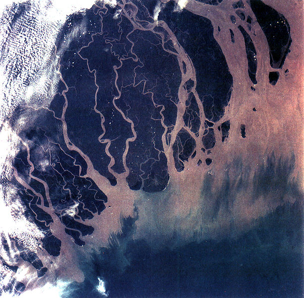
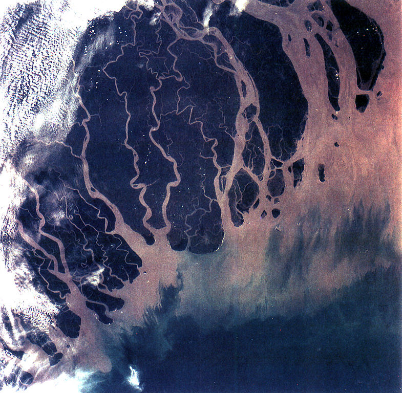
The Ganges River Delta (fig. 5) is the largest inter-tidal delta in the world. With its extensive mangrove mud flats, swamp vegetation and sand dunes, it is characteristic of many tropical and subtropical coasts. The vegetation cushions the shoreline from wind and wave action while the mangrove trees provide a habitat and food for aquatic and terrestrial plant and animal life. The increasing demand for lumber and firewood is outpacing the natural re-growth of the mangrove trees. Space Shuttle photographs, taken over time, permit monitoring of environmental changes in the delta caused by population pressures, and allows mapping of geological changes caused by shifting distributaries and delta growth. As seen in this photograph, the tributaries and distributaries of the Ganges and Brahmaputra Rivers deposit huge amounts of silt and clay that create a shifting maze of waterways and islands in the Bay of Bengal. |
| Datum | |
| Bron | https://eol.jsc.nasa.gov/SearchPhotos/photo.pl?mission=STS066&roll=92&frame=013 |
| Auteur | NASA |
Deze afbeelding of video is gecatalogiseerd door Johnson Space Center van de Verenigde Staten National Aeronautics and Space Administration (NASA)onder Foto ID: STS066-92-013.Deze banner zegt niets over de auteursrechten die van toepassing zijn. Een normale auteursrechten-tag is nodig. Zie Commons:Licensing voor meer informatie. Andere talen:
|
Licentie
| Dit bestand bevindt zich in het publiek domein, omdat het gemaakt is door de NASA. In de reproductierichtlijnen van de NASA staat dat "NASA-materiaal niet beschermd wordt door auteursrecht, tenzij anders vermeld". | ||
 |
Waarschuwingen:
|
Bestandsgeschiedenis
Klik op een datum/tijd om het bestand te zien zoals het destijds was.
| Datum/tijd | Miniatuur | Afmetingen | Gebruiker | Opmerking | |
|---|---|---|---|---|---|
| huidige versie | 25 okt 2005 22:07 | | 1.400 × 1.370 (805 kB) | Brian0918 | GANGES RIVER DELTA, BANGLADESH, INDIA (STS066-92-013). The Ganges River Delta (fig. 5) is the largest inter-tidal delta in the world. With its extensive mangrove mud flats, swamp vegetation and sand dunes, it is characteristic of many tropical and subtr |
Bestandsgebruik
Dit bestand wordt op de volgende pagina gebruikt:
Globaal bestandsgebruik
De volgende andere wiki's gebruiken dit bestand:
- Gebruikt op ar.teknopedia.teknokrat.ac.id
- Gebruikt op ast.wikipedia.org
- Gebruikt op bh.wikipedia.org
- Gebruikt op bn.wikipedia.org
- Gebruikt op br.wikipedia.org
- Gebruikt op ca.wikipedia.org
- Gebruikt op cs.wikipedia.org
- Gebruikt op cy.wikipedia.org
- Gebruikt op da.wikipedia.org
- Gebruikt op en.wikipedia.org
- Geography of Bangladesh
- River delta
- Geography of West Bengal
- Water politics
- Geology of Bangladesh
- Ganges water dispute
- Portal:Geography/Featured picture/2009, week 39
- Portal:Geography/Featured picture archive/2009
- Outline of geography
- User:Bettymnz4/Geology of Bangladesh
- Flood pulse concept
- User talk:Vsmith/Archive27
- Deltaic lobe
- Gebruikt op eo.wikipedia.org
- Gebruikt op es.teknopedia.teknokrat.ac.id
- Gebruikt op et.wikipedia.org
- Gebruikt op eu.wikipedia.org
- Gebruikt op ext.wikipedia.org
- Gebruikt op fr.teknopedia.teknokrat.ac.id
- Gebruikt op gl.wikipedia.org
- Gebruikt op hif.wikipedia.org
- Gebruikt op hi.wikipedia.org
Globaal gebruik van dit bestand bekijken.