Grootte van deze voorvertoning: 800 × 500 pixels. Andere resoluties: 320 × 200 pixels | 640 × 400 pixels | 891 × 557 pixels.
Oorspronkelijk bestand (891 × 557 pixels, bestandsgrootte: 155 kB, MIME-type: image/jpeg)
Bestandsgeschiedenis
Klik op een datum/tijd om het bestand te zien zoals het destijds was.
| Datum/tijd | Miniatuur | Afmetingen | Gebruiker | Opmerking | |
|---|---|---|---|---|---|
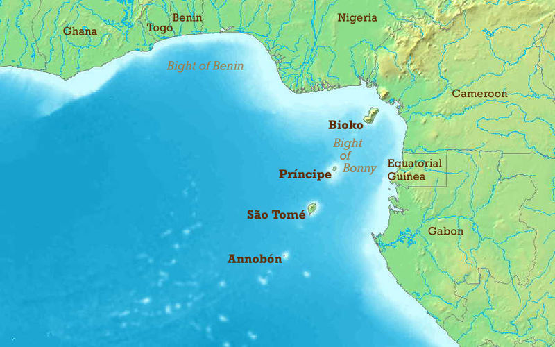
| huidige versie | 23 mei 2006 21:50 |  | 891 × 557 (155 kB) | Amcaja | The Gulf of Guinea with English labels. Map modified from Image:Golf von Guinea.jpg. {{GFDL}} Category:Guinea Category:Islands Category:Maps of the Atlantic Ocean Category:Maps of Benin Category:Maps of Cameroon [[Category:Maps |
Bestandsgebruik
Geen enkele pagina gebruikt dit bestand.
Globaal bestandsgebruik
De volgende andere wiki's gebruiken dit bestand:
- Gebruikt op af.wikipedia.org
- Gebruikt op ann.wikipedia.org
- Gebruikt op ar.teknopedia.teknokrat.ac.id
- Gebruikt op ast.wikipedia.org
- Gebruikt op azb.wikipedia.org
- Gebruikt op az.wikipedia.org
- Gebruikt op be-tarask.wikipedia.org
- Gebruikt op be.wikipedia.org
- Gebruikt op bg.wikipedia.org
- Gebruikt op bh.wikipedia.org
- Gebruikt op bn.wikipedia.org
- Gebruikt op br.wikipedia.org
- Gebruikt op bs.wikipedia.org
- Gebruikt op ca.wikipedia.org
- Golf de Benín
- Selva de terres baixes de São Tomé, Principe i Annobón
- Llista d'aeroports de São Tomé i Príncipe
- Frontera entre el Gabon i São Tomé i Príncipe
- Frontera entre Nigèria i São Tomé i Príncipe
- Frontera entre Guinea Equatorial i Nigèria
- Resolució 2018 del Consell de Seguretat de les Nacions Unides
- Gebruikt op cs.wikipedia.org
- Gebruikt op cv.wikipedia.org
- Gebruikt op cy.wikipedia.org
- Gebruikt op da.wikipedia.org
- Gebruikt op de.teknopedia.teknokrat.ac.id
- Gebruikt op el.wikipedia.org
- Gebruikt op en.wikipedia.org
Globaal gebruik van dit bestand bekijken.


