


Grootte van deze voorvertoning: 507 × 600 pixels. Andere resoluties: 203 × 240 pixels | 406 × 480 pixels | 649 × 768 pixels | 866 × 1.024 pixels | 1.732 × 2.048 pixels | 2.810 × 3.323 pixels.
Oorspronkelijk bestand (2.810 × 3.323 pixels, bestandsgrootte: 511 kB, MIME-type: image/png)
Dit is een bestand van Wikimedia Commons.
Onderstaande beschrijving komt van de beschrijving van het bestand daar.
Onderstaande beschrijving komt van de beschrijving van het bestand daar.
Beschrijving
| Beschrijving |
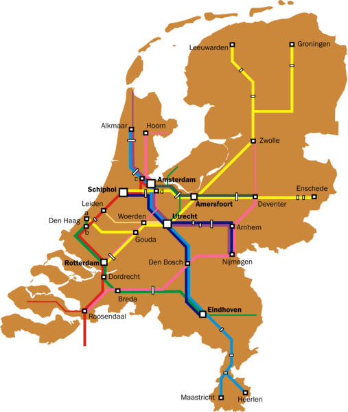
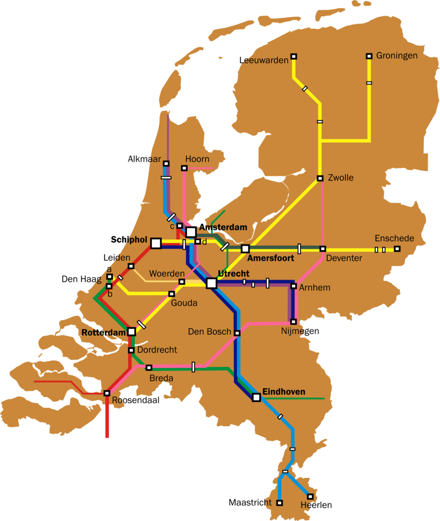
English: Map of the Dutch Intercity network. Thin lines are used for all-stops services that are a continuation of intercity services (e.g. the Rotterdam-Gouda-Amsterdam leg of the Enkhuizen-Rotterdam trains, and the Roosendaal - Vlissingen leg of the Amsterdam-Vlissingen trains).
Further notes:
|
| Datum | |
| Bron | Eigen werk |
| Auteur | Classical geographer |
| Andere versies | Intercitynet_NL_2010.png, the most recent version. |
Licentie
Ik, de auteursrechthebbende van dit werk, maak het hierbij onder de volgende licentie beschikbaar:
Dit bestand is gelicenseerd onder de Creative Commons-licentie Naamsvermelding 3.0 Unported
- De gebruiker mag:
- Delen – het werk kopiëren, verspreiden en doorgeven
- Remixen – afgeleide werken maken
- Onder de volgende voorwaarden:
- naamsvermelding – U moet op een gepaste manier aan naamsvermelding doen, een link naar de licentie geven, en aangeven of er wijzigingen in het werk zijn aangebracht. U mag dit op elke redelijke manier doen, maar niet zodanig dat de indruk wordt gewekt dat de licentiegever instemt met uw werk of uw gebruik van zijn werk.
Bestandsgeschiedenis
Klik op een datum/tijd om het bestand te zien zoals het destijds was.
| Datum/tijd | Miniatuur | Afmetingen | Gebruiker | Opmerking | |
|---|---|---|---|---|---|
| huidige versie | 5 aug 2011 18:36 | | 2.810 × 3.323 (511 kB) | Classical geographer | {{Information |Description ={{en|1=Map of the Dutch Intercity network. Thin lines are used for all-stops services that are a continuation of intercity services (e.g. the Rotterdam-Gouda-Amsterdam leg of the Enkhuizen-Rotterdam trains, and the Roosendaa |
Bestandsgebruik
Dit bestand wordt op de volgende pagina gebruikt: