


Oorspronkelijk bestand (906 × 595 pixels, bestandsgrootte: 172 kB, MIME-type: image/jpeg)
Onderstaande beschrijving komt van de beschrijving van het bestand daar.
Beschrijving
| Beschrijving |
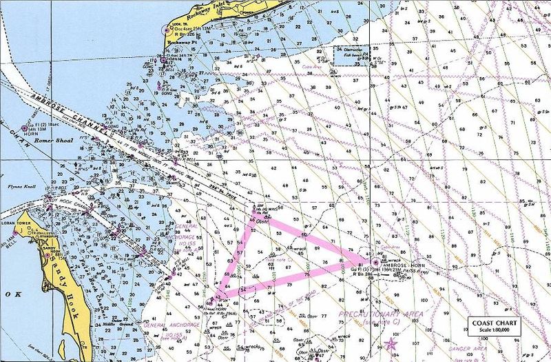
Nautical chart including LORAN TD lines for ocean approaches to New York Harbor. The chart shows TD lines, apparently for LORAN-A, which would make it the Nantucket-Chatam-Montuck-Sandy Hook-Fenwick-Bodie Is-Cape Hatteras chain. Note that the printed TD lines do not extend into inland waterway areas, as LORAN propagates poorly over land. The green 1000 lines curve heavily in this area. Note the "LORAN TR" mark at the tip of Sandy Hook near the focus of the curves. This would be Station "J" (3H5). The ochre 4000 lines (3H4) would correspond to the TD between the master and Station "H" at Cape Hatteras. The master station of this chain was at Sankaty Head on Nantucket, Massachussets. [1] The sharp angle between these sets of TD rings, especially to the east and north, would make it a poor pair for precise navigation. This is a detail of the original at:
|
| Datum | 18 december 2004 (originele uploaddatum) |
| Bron |
Perry-Castañeda Map Collection, University of Texas at Austin - Original URL (detail) - Copyright statement Originally uploaded on en.wikipedia; the description page was written by User:KeithTyler, and imported from here. |
| Auteur | Onbekend |
| Toestemming (Hergebruik van dit bestand) |
PD-LAYOUT; PD-USGOV. |
![[2]](http://www.lib.utexas.edu/maps/national_atlas_1970/ca000219.jpg)
Licentie
Dit werk bevindt zich in het publieke domein in de Verenigde Staten omdat het is vervaardigd door een ambtenaar van de Amerikaanse federale overheid tijdens de uitoefening van zijn functie, en het daarmee volgens Titel 17, Hoofdstuk 1, Sectie 105 van de United States Code [Engelstalige link] een werk van de Amerikaanse federale overheid [Engelstalige link] is.
Nota bene: Het bovenstaande is alleen van toepassing op werken van de federale overheid of een van haar onderdelen, en niet op werken van een afzonderlijk(e) Staat, Territorium, Commonwealth, County, Gemeente, of enig andere bestuurlijke eenheid. Dit sjabloon is ook niet van toepassing op ontwerpen voor postzegels, door de United States Postal Service openbaar gemaakt sinds 1978 [Engelstalige link]. Zie Art. 206.02(b) van "Compendium II: Copyright Office Practices" (Engelstalig).
|
 | |
| Van dit bestand is vastgesteld dat er geen bekende auteursrechtaanspraken op rusten, alle aanverwante en naburige rechten daarbij inbegrepen. | ||
Bestandsgeschiedenis
Klik op een datum/tijd om het bestand te zien zoals het destijds was.
| Datum/tijd | Miniatuur | Afmetingen | Gebruiker | Opmerking | |
|---|---|---|---|---|---|
| huidige versie | 14 jul 2007 11:12 | | 906 × 595 (172 kB) | Massimiliano Lincetto | {{Information |Description=Nautical chart including en:LORAN TD lines for ocean approaches to New York Harbor. The chart shows TD lines, apparently for LORAN-A, which would make it the NANTUCKET-CHATHAM-MONTUCK-SANDY HOOK-FENWICK-BODIE IS-CAPE HATTE |
Bestandsgebruik
Dit bestand wordt op de volgende 2 pagina's gebruikt:
Globaal bestandsgebruik
De volgende andere wiki's gebruiken dit bestand:
- Gebruikt op en.wikipedia.org
- Gebruikt op fr.teknopedia.teknokrat.ac.id
- Gebruikt op it.teknopedia.teknokrat.ac.id
- Gebruikt op lv.wikipedia.org
- Gebruikt op ru.teknopedia.teknokrat.ac.id
- Gebruikt op sl.wikipedia.org
- Gebruikt op vi.wikipedia.org