


Afmetingen van deze voorvertoning van het type PNG van dit SVG-bestand: 800 × 592 pixels Andere resoluties: 320 × 237 pixels | 640 × 473 pixels | 1.024 × 757 pixels | 1.280 × 947 pixels | 2.560 × 1.894 pixels | 1.045 × 773 pixels.
Oorspronkelijk bestand (SVG-bestand, nominaal 1.045 × 773 pixels, bestandsgrootte: 505 kB)
| Dit is een bestand van Wikimedia Commons. Onderstaande beschrijving komt van de beschrijving van het bestand daar. |
Beschrijving
| Beschrijving |
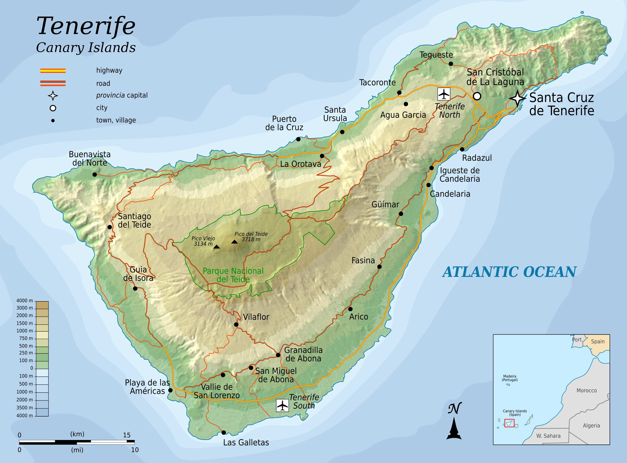
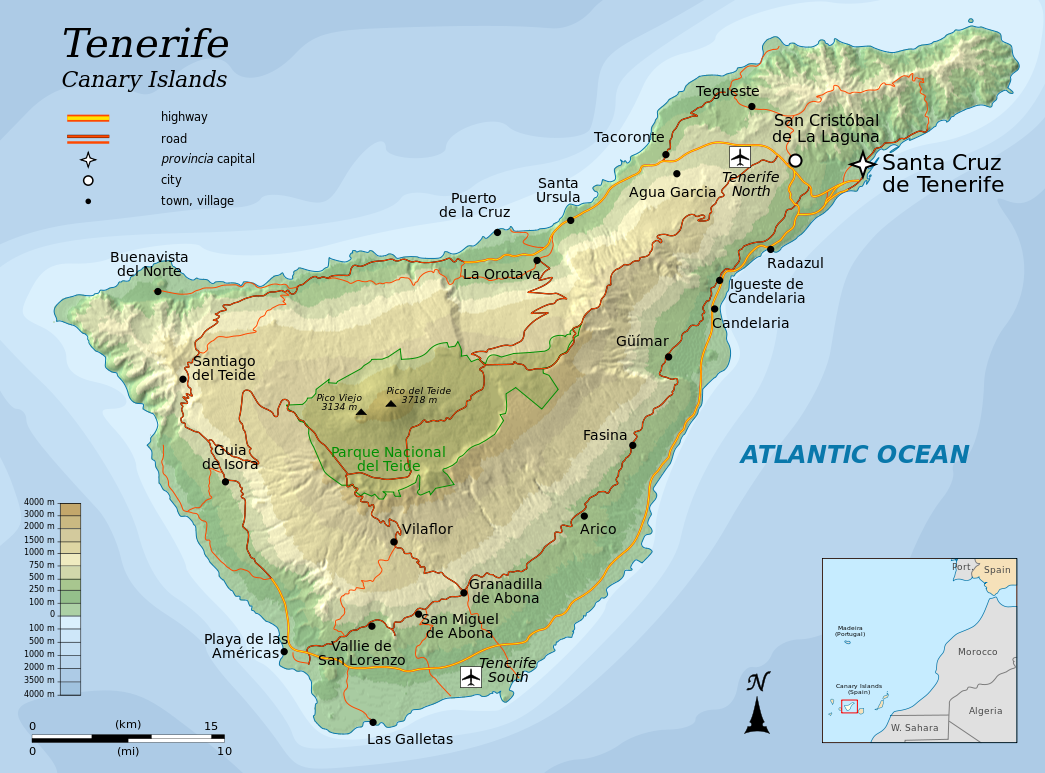
English: Topographic map of Tenerife, an island of the Canary Islands of Spain. |
| Datum | |
| Bron |
Self-made in Inkscape.
|
| Auteur | Oona Räisänen (Mysid) |
| Andere versies |
|


|
Dit SVG-bestand maakt gebruik van geïntegreerde tekst die gemakkelijk kan worden vertaald naar uw taal met een SVG editor, een tekstverwerker of het hulpmiddel SVG Translate. Uitleg |
Deze niet W3C-deugdelijke vectorafbeelding is gemaakt met Inkscape .
Licentie
Ik, de auteursrechthebbende van dit werk, maak het hierbij onder de volgende licenties beschikbaar:
Dit bestand is gelicenseerd onder de Creative Commons-licentie Naamsvermelding-Gelijk delen 3.0 Unported
- De gebruiker mag:
- Delen – het werk kopiëren, verspreiden en doorgeven
- Remixen – afgeleide werken maken
- Onder de volgende voorwaarden:
- naamsvermelding – U moet op een gepaste manier aan naamsvermelding doen, een link naar de licentie geven, en aangeven of er wijzigingen in het werk zijn aangebracht. U mag dit op elke redelijke manier doen, maar niet zodanig dat de indruk wordt gewekt dat de licentiegever instemt met uw werk of uw gebruik van zijn werk.
- Gelijk delen – Als u het werk heeft geremixt, veranderd, of erop heeft voortgebouwd, moet u het gewijzigde materiaal verspreiden onder dezelfde licentie als het oorspronkelijke werk, of een daarmee compatibele licentie.

|
Toestemming wordt verleend voor het kopiëren, verspreiden en/of wijzigen van dit document onder de voorwaarden van de GNU-licentie voor vrije documentatie, versie 1.2 of enige latere versie als gepubliceerd door de Free Software Foundation; zonder Invariant Sections, zonder Front-Cover Texts, en zonder Back-Cover Texts. Een kopie van de licentie is opgenomen in de sectie GNU-licentie voor vrije documentatie. |
U mag zelf één van de licenties kiezen.
Bestandsgeschiedenis
Klik op een datum/tijd om het bestand te zien zoals het destijds was.
| Datum/tijd | Miniatuur | Afmetingen | Gebruiker | Opmerking | |
|---|---|---|---|---|---|
| huidige versie | 6 aug 2010 08:25 | | 1.045 × 773 (505 kB) | Mysid | more roads + north reference |
| 5 aug 2010 23:45 |  | 1.045 × 773 (466 kB) | Mysid | add northern airport | |
| 5 aug 2010 22:30 |  | 1.045 × 773 (463 kB) | Mysid | fonts | |
| 5 aug 2010 22:26 |  | 1.045 × 773 (463 kB) | Mysid | {{Information |Description={{en|1=Topographic map of Tenerife, and island of the Canary Islands of Spain.}} |Source=Self-made in Inkscape. |Author=Mysid |Date=2010-08-05 |Permission= |other_versions= }} {{translation possib |
Bestandsgebruik
Dit bestand wordt op de volgende pagina gebruikt:
Globaal bestandsgebruik
De volgende andere wiki's gebruiken dit bestand:
- Gebruikt op cs.wikipedia.org
- Gebruikt op en.wikipedia.org
- Gebruikt op fi.wikipedia.org
- Gebruikt op fr.teknopedia.teknokrat.ac.id
- Gebruikt op hr.wikipedia.org
- Gebruikt op hu.wikipedia.org
- Gebruikt op ko.wikipedia.org
- Gebruikt op mr.wikipedia.org
- Gebruikt op pnb.wikipedia.org
- Gebruikt op ru.teknopedia.teknokrat.ac.id
- Gebruikt op sl.wikipedia.org
- Gebruikt op tr.wikipedia.org
- Gebruikt op zh.teknopedia.teknokrat.ac.id