


Grootte van deze voorvertoning: 800 × 343 pixels. Andere resoluties: 320 × 137 pixels | 640 × 274 pixels | 1.024 × 439 pixels | 2.206 × 946 pixels.
Oorspronkelijk bestand (2.206 × 946 pixels, bestandsgrootte: 289 kB, MIME-type: image/png)
Dit is een bestand van Wikimedia Commons.
Onderstaande beschrijving komt van de beschrijving van het bestand daar.
Onderstaande beschrijving komt van de beschrijving van het bestand daar.

|
Deze kaartafbeelding zou opnieuw moeten worden aangemaakt als een SVG-bestand door vectorafbeeldingen te gebruiken. Dit heeft een aantal voordelen; zie Commons:Media for cleanup voor meer informatie. Als er een SVG-formaat van deze afbeelding bestaat, dan deze graag uploaden. Nadat u dit heeft gedaan, gelieve dit sjabloon te vervangen door het sjabloon {{vector version available|nieuwe bestandsnaam.svg}} op deze afbeeldingspagina.
|
Beschrijving
| Beschrijving |
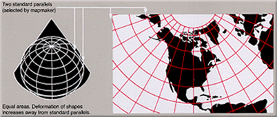
English: Condensed explanation of Albers conic-projection maps, extracted from PDF. |
|||
| Datum | ||||
| Bron | Map projections | |||
| Auteur | derived from US Government USGS | |||
| Toestemming (Hergebruik van dit bestand) |
|
|||
| Andere versies |
Narrowed image with larger lettering, taller layout, 29% compressed (GIF format): |
Bestandsgeschiedenis
Klik op een datum/tijd om het bestand te zien zoals het destijds was.
| Datum/tijd | Miniatuur | Afmetingen | Gebruiker | Opmerking | |
|---|---|---|---|---|---|
| huidige versie | 4 feb 2025 21:58 | | 2.206 × 946 (289 kB) | Mikhail Ryazanov | higher resolution |
| 17 feb 2005 16:22 |  | 402 × 170 (38 kB) | Quadell | World map projection ([http://erg.usgs.gov/isb/pubs/MapProjections/projections.html source)]{{PD-USGov-USGS}}Category:World mapsCategory:Map projectionsCategory:Map diagrams |
Bestandsgebruik
Dit bestand wordt op de volgende pagina gebruikt:
Globaal bestandsgebruik
Dit bestand wordt op de volgende andere wiki’s gebruikt:
- Gebruikt op en.wikipedia.org
- Gebruikt op es.teknopedia.teknokrat.ac.id
- Gebruikt op fi.wikipedia.org
- Gebruikt op it.teknopedia.teknokrat.ac.id
- Gebruikt op ja.wikipedia.org
- Gebruikt op pt.teknopedia.teknokrat.ac.id
- Gebruikt op ru.teknopedia.teknokrat.ac.id
- Gebruikt op zh-yue.wikipedia.org
- Gebruikt op zh.teknopedia.teknokrat.ac.id