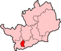
| Niet-metropolitaans district in Engeland | |||
|---|---|---|---|
 
| |||
| Situering | |||
| Land | Engeland | ||
| County | Hertfordshire | ||
| Regio | East of England | ||
| Coördinaten | 51°39'19"NB, 0°23'45"WL | ||
| Algemeen | |||
| Oppervlakte | 21,4305[1] km² | ||
| Inwoners (2018[2]) |
96.767 (4515 inw./km²) | ||
| ONS-code | E07000103 | ||
| Website | www | ||
| Detailkaart | |||

| |||
| |||
Watford is een city en een district ten noordwesten van Londen in shire-graafschap (non-metropolitan county OF county) Hertfordshire. De stad heeft 97.000 inwoners.
Watford wordt voor het eerst vermeld in het testament van Ethelgifu, de vrouw van koning Edmund I van Engeland, in 946.
In de twaalfde eeuw kreeg Watford het recht om markt te houden.
Daniel Defoe beschreef de stad in 1724 als volgt: "Very long, having but one street". Dat is vandaag de dag nog steeds zo.
In 1837 kreeg Watford een station, Watford Junction, op de lijn Londen–Birmingham. Daardoor kwam de hoofdstad binnen het bereik van pendelaars en ontwikkelde Watford zich als een voorstad van Londen. Sinds 1925 wordt de stad ook bereikt door de Metropolitan Line van de Londense metro.
Sport
Watford geniet vooral bekendheid dankzij zijn betaaldvoetbalclub Watford FC. Watford FC speelt zijn wedstrijden in het stadion Vicarage Road.
Geboren
- Gerald Moore (1899-1987), pianist
- Bruce Alexander (1946), acteur
- Mo Mowlam (1949-2005), politica
- Julie Forsyth (1958), zangeres (Guys 'n' Dolls, Grant & Forsyth)
- Robert Glenister (1960), acteur
- Bradley Walsh (1960), acteur en televisiepresentator
- Vinnie Jones (1965), voetballer en acteur
- Gareth Southgate (1970), voetballer en voetbalcoach
- Ian Walker (1971), voetballer
- Geri Halliwell (1972), zangeres (voormalig lid van Spice Girls)
- Alex Roy (1974), darter
- Matt Redman (1974), liedjesschrijver
- Delta White (1981), actrice en model
- Jack Collison (1988), Welsh voetballer
- Anthony Joshua (1989), bokser
- Olajide Olatunji (1993), internetbekendheid
- Charlotte Beaumont (1995), actrice
- Charlie Patino (2003), voetballer
- ↑ Office for National Statistics → Download → SAM_for_Administrative_Areas_(2018).zip → SAM_LAD_DEC_2018_UK.xlsx.
- ↑ https://www.ons.gov.uk/file?uri=/peoplepopulationandcommunity/populationandmigration/populationestimates/datasets/populationestimatesforukenglandandwalesscotlandandnorthernireland/mid20182019laboundaries/ukmidyearestimates20182019ladcodes.xls Schatting Office for National Statistics: knop MYE5 → kolom Estimated Population mid-2018]


